
The Sweco Group is the largest technical consulting company in Scandinavia. It has brought its expertise in sustainable engineering to over a hundred countries. When Sweco needed advanced editing features formerly unknown on the web, they came to OpenGeo. Now these features are a core part of OpenLayers.
The Edge
Sweco Position is a member company of the Sweco Group that specializes in GIS solutions. they were building a new geographic platform for the Swedish Postal Service using the OpenGeo stack: PostGIS, GeoServer, OpenLayers, and ExtJS. One of their applications, MyWay, lets users edit road, bike, and walking routes in order to optimize postal deliveries.
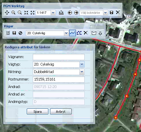
Editing route data in MyWay
Something important was missing. Road network data has a certain topology; it is important that road and path features connect exactly from end to end. For somebody editing a map by hand, this is impossible to maintain without advanced editing features: easy ways to "snap" one feature's vertex to another's and "split" a feature to create new vertices.
But snapping and splitting were at the time unknown in web GIS editing. Most people thought only desktop editors could do them.
The Expert
Sweco's Andreas Oxenstierna knew that the open source, geospatial web was up to the task. He also knew that for the fastest, highest quality solution he should contact the experts. So Oxenstierna brought designs for what Sweco needed to OpenGeo. Tim Schaub, one of OpenGeo's OpenLayers adepts, was eager to take the project on.
"It's exciting to bring things into the browser that people think are reserved for expensive proprietary desktop software," says Schaub, who is now chair of the OpenLayers project steering committee.
The Action
Schaub quickly developed the new features for OpenLayers and brought them into the project's core. It was cutting edge work with lightning fast turnaround. Sweco Position continued on with its project, and OpenLayers now has advanced vector editing features, available to all.
"We really appreciated working together with Tim and OpenGeo," reminisces Oxenstierna.
Experience advanced vector editing yourself with the OpenLayers Snapping and Splitting Example.
Other Case Studies
Greek Regulatory Authority for Energy
The Greek Regulatory Authority for Energy (RAE) Geospatial Map is a web application developed by GET, created during RAE’s Spatial Data Infrastructure implementation. Development was based on: GED SDI Portal®, created and distributed by GET Ltd., under GPL V3, OpenGeo Suite, and Geonetwork OpenSource.
City of New York: A Hybrid Architecture
The City of New York Department of IT built a mapping architecture mixing proprietary and open source components to serve maps for multiple agencies and applications.
MassGIS: A GeoServer Enterprise Story

OpenGeo provides enterprise GeoServer support for Massachussetts' GIS agency.
Rijkswaterstaat: Connected to Open Source
Rijkswaterstaat calls on OpenGeo to build new open source features and add them back into the core project.
FCC Uses Open Source Tools for National Broadband Map
The Federal Communication Commission's National Broadband Map enables the public to see where broadband coverage is available in the United States. The site is completely powered by open source software including PostGIS, GeoServer, OpenLayers, Wordpress, Linux and Apache.
EBServices uses the OpenGeo Suite to deliver a spatial data extra service to SP-Ausnet a power company in the state of Victoria, Australia.

The City of Asheville’s two highly popular GIS applications, Steep Slope and Priority Places, were improved by implementing a hybrid architecture to include both ESRI and open source components.

OpenGeo provides enterprise support to Portland's regional transit authority, who have built a trip planner using the OpenGeo suite of products.
TsuDat: GeoNode and Disaster Modelling

GeoScience Australia and AIFDR have used web delivery to make tsunami modelling available to emergency managers across Australia in a way that was never possible before.

OpenGeo provides a collaborative map for Landgate, Western Australia's land data authority, using OpenLayers and a Versioning extension to the Web Feature Service Standard.
Tike : GeoServer Enterprise Support

Finnish IT agency Tike brings in OpenGeo to provide production support for GeoServer and custom development of web front-end tools.
International technical consulting firm Sweco hires OpenGeo to build cutting edge feature editing capabilities to the OpenLayers core.
Farallon: San Francisco Enterprise Addressing System

Farallon, an OpenGeo partner, develops a secure, web-based solution for the San Francisco Enterprise Addressing System using open source geospatial technology.