
The Situation
Landgate knows nearly everything about Western Australia. As the government authority responsible for land and property information, Landgate's data underpins hundreds of civil services, from rubbish pickup to education to immigration.
Data maintenance is a huge burden for agencies like Landgate.
“Individual departments were all keeping their own databases. We had invested a lot in getting these databases up-to-date, and we wanted a better way to maintain them,” explains Kylie Armstrong, Manager of Business Programs at Landgate.
“Crowdsourced” maps offered an elegant solution. As with Wikipedia - where many editors add and update articles - a crowdsourced map distributes the work of content maintenance of many contributors.
Choosing OpenGeo
“With the influx of Google and others who offer loads of data right at your fingertips, we needed a smart way to provide the same high quality data services,” says Kylie.
Landgate had a shared land information platform, built using a combination of open source and proprietary software. The system that could handle data used by more than 20 agencies, for more than 200 services. Mapped data is a powerful aid to evidence based policy.
GeoServer and PostGIS were key components, and when Landgate wanted to build a crowdsourced map, they turned to OpenGeo for help. OpenGeo's expertise in the geospatial technologies delivered.
“It was great,” says Kylie. “We got things on time.”
Crowdsourcing
The goal was to create a mapping system where users in different agencies could review and update changes to geospatial data.
Landgate's crowdsourcing map had four distinct feature needs:
- Global History - Users needed a clear history of all the changes that had been made on the map.
- Feature Specific History - Each data point needed its own history, so that users could track and review changes to the map.
- Feature Specific Diff - Users needed the ability to compare the different versions of the same feature to see how its attributes and position had changed.
- Feature-specific Rollback - In case of editing mistakes or 'vandalism,' the map needed to make it easy to roll back feature to a previous state.
User's commands to add and update features used the OGC Web Feature Service standard. For the history, “diff”, and rollback functions needed for a truly crowdsourced map, OpenGeo used WFS-Versioning, an extension to the standard that GeoServer supports.
Taking On The Challenge
OpenGeo built Landgate's crowdsourcing solution using Vespucci, a collaborative mapping framework originally built for the Livable Streets Movement. Vespucci combines the power of OpenLayers as a mapping front-end, GeoServer's support for versioned editing, and OpenGeo's design talent in one tight package.
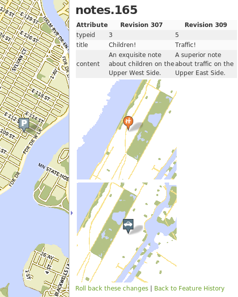
Viewing a feature diff in Vespucci.
One of OpenGeo's OpenLayers experts took on both the work of adding the new crowdsourcing features to Vespucci and responding promptly to the questions and comments of his counterpart at Landgate.
Landgate received their crowdsourced map on time and as desired.
Happy Customers
“People are just loving it,” reports Kylie. “This project is going really well. We've been demonstrating [the crowdsourcing map] to a whole range of government departments, and internally.”
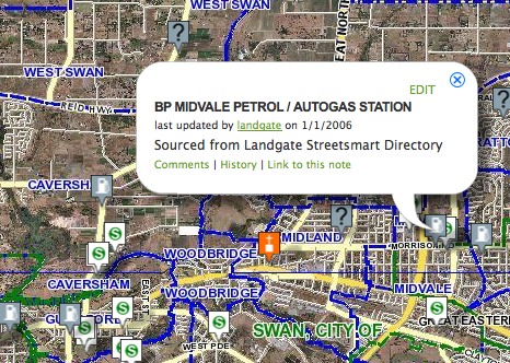
Screenshot from Landgate's crowdsourced map.
Other Case Studies
Greek Regulatory Authority for Energy
The Greek Regulatory Authority for Energy (RAE) Geospatial Map is a web application developed by GET, created during RAE’s Spatial Data Infrastructure implementation. Development was based on: GED SDI Portal®, created and distributed by GET Ltd., under GPL V3, OpenGeo Suite, and Geonetwork OpenSource.
City of New York: A Hybrid Architecture
The City of New York Department of IT built a mapping architecture mixing proprietary and open source components to serve maps for multiple agencies and applications.
MassGIS: A GeoServer Enterprise Story

OpenGeo provides enterprise GeoServer support for Massachussetts' GIS agency.
Rijkswaterstaat: Connected to Open Source
Rijkswaterstaat calls on OpenGeo to build new open source features and add them back into the core project.
FCC Uses Open Source Tools for National Broadband Map
The Federal Communication Commission's National Broadband Map enables the public to see where broadband coverage is available in the United States. The site is completely powered by open source software including PostGIS, GeoServer, OpenLayers, Wordpress, Linux and Apache.
EBServices uses the OpenGeo Suite to deliver a spatial data extra service to SP-Ausnet a power company in the state of Victoria, Australia.

The City of Asheville’s two highly popular GIS applications, Steep Slope and Priority Places, were improved by implementing a hybrid architecture to include both ESRI and open source components.

OpenGeo provides enterprise support to Portland's regional transit authority, who have built a trip planner using the OpenGeo suite of products.
TsuDat: GeoNode and Disaster Modelling

GeoScience Australia and AIFDR have used web delivery to make tsunami modelling available to emergency managers across Australia in a way that was never possible before.
OpenGeo provides a collaborative map for Landgate, Western Australia's land data authority, using OpenLayers and a Versioning extension to the Web Feature Service Standard.
Tike : GeoServer Enterprise Support

Finnish IT agency Tike brings in OpenGeo to provide production support for GeoServer and custom development of web front-end tools.

International technical consulting firm Sweco hires OpenGeo to build cutting edge feature editing capabilities to the OpenLayers core.
Farallon: San Francisco Enterprise Addressing System

Farallon, an OpenGeo partner, develops a secure, web-based solution for the San Francisco Enterprise Addressing System using open source geospatial technology.