“We knew that this was an important project that would generate interest, but no one was prepared to have to meet peaks of up to 9,000 requests per second. … Support from Cloudmade and OpenGeo was critical in these initial moments, and in my opinion they did an excellent job supporting this launch.”
— Juan Marín Otero, Computech: project lead for the National Broadband Map
Introduction
![]() When Michael Byrne began his tenure as GIO of the Federal Communications Commission (FCC) he was greeted with significant challenges. A recent congressional mandate made the FCC responsible for creating and delivering a national map of broadband access. This map had to deliver a fast and efficient service, and promote the use of open data sets. Users would gain the means to explore and visualize a vast array of data over high-speed internet connections. Developers would acquire access to a wide range of open data APIs to create their own applications. As if these expectations weren't high enough, Congress placed a one year deadline on the project.
When Michael Byrne began his tenure as GIO of the Federal Communications Commission (FCC) he was greeted with significant challenges. A recent congressional mandate made the FCC responsible for creating and delivering a national map of broadband access. This map had to deliver a fast and efficient service, and promote the use of open data sets. Users would gain the means to explore and visualize a vast array of data over high-speed internet connections. Developers would acquire access to a wide range of open data APIs to create their own applications. As if these expectations weren't high enough, Congress placed a one year deadline on the project.
Under the pressure of a congressional deadline, Byrne and his team launched broadband and created the National Broadband Map. The National Broadband Map features open architecture and was built completely with open source tools. The FCC also delivered open data and seven new APIs for querying FCC information. They adopted an open REST architecture to allow direct public access to FCC information.
Juan Marín, the project lead from Computech reflected on the project's early efforts: “First we built a prototype using the proprietary software we already had in-house, which was a good learning experience. While we were able to get a map up and running, the operational complexity we experienced managing the software, and the speed we measured off the prototype, showed we needed to look at a different software solution.”
Development of an Open Source Solution
With only six months until the broadband launch, the team began building out the production site using the OpenGeo Suite of open source software: PostGIS, GeoServer, and OpenLayers. Portions of the prototype, such as the Oracle-based data querying API, were kept and used in production. Other parts, such as the map generation and user interface, were moved to the OpenGeo tools. For development support, the Computech team acquired an OpenGeo Suite support contract.
As the team neared their delivery date, they load tested to ensure they could handle the 100,000 visits they expected when the site launched. However, on launch day, the site was profiled in the New York Times and on morning television shows — on launch-day the actual number of visitors was over 500,000, with a peak load of 9,000 requests per second. The site stayed online, and new mapping servers were pressed into service during to handle the traffic. The technical foundation of broadband is a modular, web-centric approach to architecture:
- Under the covers, database access is via Hibernate, which makes the system database agnostic;
- All data used is exposed via REST web services;
- All mapping is done using OGC-standard protocols; and,
- The front-end user interface of broadband only consumes the public web services, so everything the site displays is open for third party developers to re-mix and mash-up.
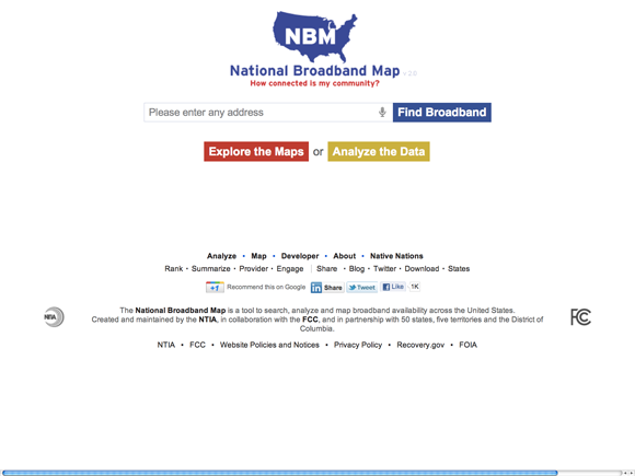 Figure 1.
The login page prompts a user to search the map by address.
Figure 1.
The login page prompts a user to search the map by address.
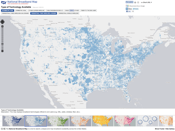 Figure 2.
The map itself allows full interaction to zoom and pan. There are various preset searches listed as gallery items on the bottom menu and data sets that can be toggled from the top menu.
Figure 2.
The map itself allows full interaction to zoom and pan. There are various preset searches listed as gallery items on the bottom menu and data sets that can be toggled from the top menu.
Redistributable under the Creative Commons Attribution-Share Alike license.
Table of Contents
Other Case Studies
Greek Regulatory Authority for Energy
The Greek Regulatory Authority for Energy (RAE) Geospatial Map is a web application developed by GET, created during RAE’s Spatial Data Infrastructure implementation. Development was based on: GED SDI Portal®, created and distributed by GET Ltd., under GPL V3, OpenGeo Suite, and Geonetwork OpenSource.
City of New York: A Hybrid Architecture
The City of New York Department of IT built a mapping architecture mixing proprietary and open source components to serve maps for multiple agencies and applications.
MassGIS: A GeoServer Enterprise Story

OpenGeo provides enterprise GeoServer support for Massachussetts' GIS agency.
Rijkswaterstaat: Connected to Open Source
Rijkswaterstaat calls on OpenGeo to build new open source features and add them back into the core project.
FCC Uses Open Source Tools for National Broadband Map
The Federal Communication Commission's National Broadband Map enables the public to see where broadband coverage is available in the United States. The site is completely powered by open source software including PostGIS, GeoServer, OpenLayers, Wordpress, Linux and Apache.
EBServices uses the OpenGeo Suite to deliver a spatial data extra service to SP-Ausnet a power company in the state of Victoria, Australia.

The City of Asheville’s two highly popular GIS applications, Steep Slope and Priority Places, were improved by implementing a hybrid architecture to include both ESRI and open source components.

OpenGeo provides enterprise support to Portland's regional transit authority, who have built a trip planner using the OpenGeo suite of products.
TsuDat: GeoNode and Disaster Modelling

GeoScience Australia and AIFDR have used web delivery to make tsunami modelling available to emergency managers across Australia in a way that was never possible before.

OpenGeo provides a collaborative map for Landgate, Western Australia's land data authority, using OpenLayers and a Versioning extension to the Web Feature Service Standard.
Tike : GeoServer Enterprise Support

Finnish IT agency Tike brings in OpenGeo to provide production support for GeoServer and custom development of web front-end tools.

International technical consulting firm Sweco hires OpenGeo to build cutting edge feature editing capabilities to the OpenLayers core.
Farallon: San Francisco Enterprise Addressing System

Farallon, an OpenGeo partner, develops a secure, web-based solution for the San Francisco Enterprise Addressing System using open source geospatial technology.