EB Services, an IT consultancy servicing the utility sector manages the Smallworld installation at SP-Ausnet, a power company in the state of Victoria, Australia.
EB Services saw an opportunity to provide better service for their customer. They evaluated options and quickly realized that they could spend a lot of time developing a custom solution, spend a lot of money licensing a solution or evaluate an open source solution. The expense of a custom solution was deemed to high, and licensing was considered risky in that the customer might not consider the problem a high priority.
Simon Bond, who works for EBS on SP-Ausnet projects noted: “I noticed through discussions with our client that we were continually getting requests for extracts of data from their Smallworld system. This required one of us to write code to perform extracts. This was a very time consuming process which led to two further problems: the first is that the data didn’t always get to the user in a timeframe that was of maximum use; the second is that the users became more likely to use old unmanaged data.”
 Enter the OpenGeo Suite. The Suite provided an out-of-the-box set-up, with the flexibility to customize a tool for performing data extractions. The price was competitive with other solutions, and the web-based nature of the system made deployment and updates easy. The many extra features of the Suite, beyond simple query and data extraction, offered a potential road map for future features.
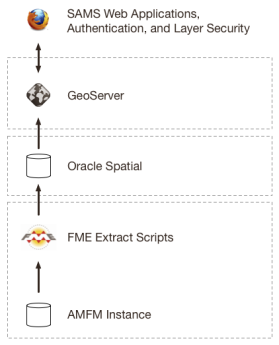
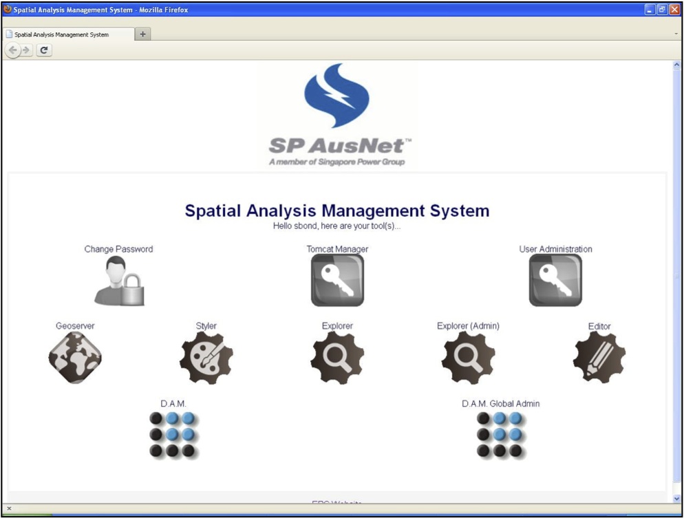
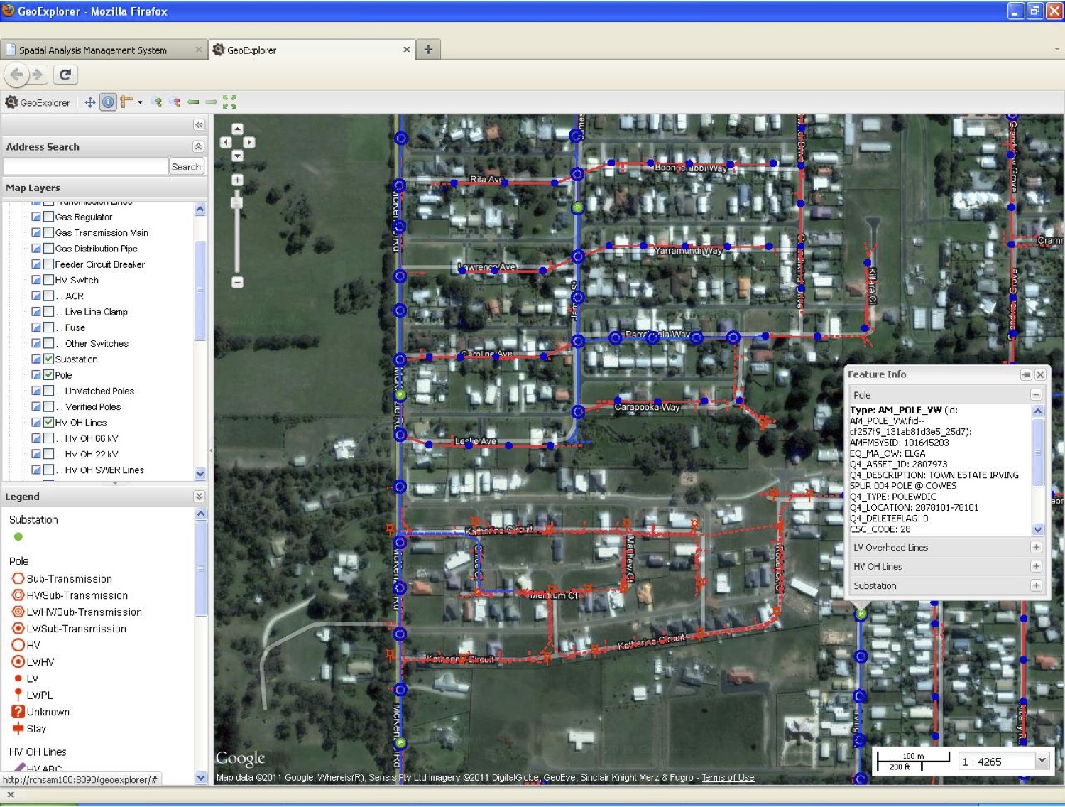
Bond used the Suite to build a the Spatial Analysis Management System (SAMS), a web-based extract tool pulling data from Smallworld into a staging Oracle Spatial database via FME, and then out to the web using GeoServer and the web UI tools of the Suite.
“We have already gone into production with our first version of our customized OpenGeo Application Suite”, said Bond, “and it recently came second in the GITA Excellence awards! It has been very well received by the users so far with over 120 users in the first month and 100% uptime.”
SAMS is now being used by a wide range of people across Ausnet, including control room staff, designers, work management and planning, call centre staff, management and others.
With the success of SAMS, EBS is now investigating further enhancements, including a mobile SAMS implementation, integration with Google Street View, integration with the Ausnet asset management system and more.
Other Case Studies
Greek Regulatory Authority for Energy
The Greek Regulatory Authority for Energy (RAE) Geospatial Map is a web application developed by GET, created during RAE’s Spatial Data Infrastructure implementation. Development was based on: GED SDI Portal®, created and distributed by GET Ltd., under GPL V3, OpenGeo Suite, and Geonetwork OpenSource.
City of New York: A Hybrid Architecture
The City of New York Department of IT built a mapping architecture mixing proprietary and open source components to serve maps for multiple agencies and applications.
MassGIS: A GeoServer Enterprise Story

OpenGeo provides enterprise GeoServer support for Massachussetts' GIS agency.
Rijkswaterstaat: Connected to Open Source
Rijkswaterstaat calls on OpenGeo to build new open source features and add them back into the core project.
FCC Uses Open Source Tools for National Broadband Map
The Federal Communication Commission's National Broadband Map enables the public to see where broadband coverage is available in the United States. The site is completely powered by open source software including PostGIS, GeoServer, OpenLayers, Wordpress, Linux and Apache.
EBServices uses the OpenGeo Suite to deliver a spatial data extra service to SP-Ausnet a power company in the state of Victoria, Australia.

The City of Asheville’s two highly popular GIS applications, Steep Slope and Priority Places, were improved by implementing a hybrid architecture to include both ESRI and open source components.

OpenGeo provides enterprise support to Portland's regional transit authority, who have built a trip planner using the OpenGeo suite of products.
TsuDat: GeoNode and Disaster Modelling

GeoScience Australia and AIFDR have used web delivery to make tsunami modelling available to emergency managers across Australia in a way that was never possible before.

OpenGeo provides a collaborative map for Landgate, Western Australia's land data authority, using OpenLayers and a Versioning extension to the Web Feature Service Standard.
Tike : GeoServer Enterprise Support

Finnish IT agency Tike brings in OpenGeo to provide production support for GeoServer and custom development of web front-end tools.

International technical consulting firm Sweco hires OpenGeo to build cutting edge feature editing capabilities to the OpenLayers core.
Farallon: San Francisco Enterprise Addressing System

Farallon, an OpenGeo partner, develops a secure, web-based solution for the San Francisco Enterprise Addressing System using open source geospatial technology.