“With a goal of better serving the needs of city staff and the public, the team developed a set of applications intended to be cost effective, comprehensive and sustainable. The user base has increased by 20% and maintenance costs have decreased.”
—North Carolina Geographic Information Coordinating Council
Introduction
The City of Asheville's two highly popular GIS applications, Steep Slope and Priority Places, were improved by implementing a hybrid architecture to include both ESRI and open source components. Developers found they achieved performance gains, improved reliability, and increased flexibility to these applications by adding the open source components PostGIS, GeoServer, and GeoWebCache.
The GIS department for the City of Asheville, North Carolina has a straightforward objective: acquiring, developing, serving, and maintaining geospatial data to support the city's public services and internal business functions. Rather than devote internal resources to data capture, the department creates GIS applications that directly address the needs of Asheville's citizens by serving existing data in innovative ways.
Asheville's GIS team takes a pragmatic yet forward-thinking approach in its choice of technologies. Solutions must provide immediate utility without expending major costs and development effort. They must be also be sustainable — affordable, maintainable, and flexible enough to be modified and extended over the long term. OpenGeo components brought said functionality and sustainability to Steep Slope and Priority Places. Simply put, they were the best tools for the job.
Optimal Performance and Reliability: Steep Slope
Asheville's mountains and hillsides, visible throughout the city, provide both scenic vistas and space for outdoor recreation. However, these areas are sensitive to erosion and landslides. In order to maintain slope stability, the county and city regulate land development. Towards this end, The City of Asheville developed Steep Slope. Steep Slope provides a simple online tool for citizens to determine whether an area of interest is subject to either the Buncombe County Hillside Development Standards or the City of Asheville Steep Slope Ordinances.
For any user-defined area, Steep Slope first calculates the average natural percentage slope based on contour data and then determines its viability under city and county regulations. Because parcels are frequently split, merged, and corrected, boundary data are in a state of constant change. As a result, the application treats contour data as an overlay, independent from the parcel layer. Both datasets are then used to dynamically calculate the slope for the requested area.
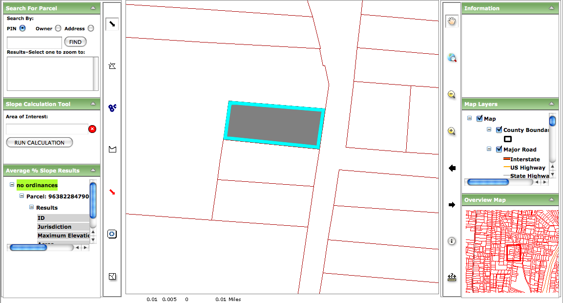 Figure 1.
Steep Slope allows a user to calculate the slope of a parcel to determine whether the area is subject to development restrictions.
Figure 1.
Steep Slope allows a user to calculate the slope of a parcel to determine whether the area is subject to development restrictions.
Calculations from early prototypes using ESRI's ArcGIS Server and WebADF were not only slow — 30 seconds to calculate the slope for a 1.2 acre lot — but also inaccurate. David Michelson, lead GIS Analyst of Steep Slope knew speed and accuracy were non-negotiable requirements for his web users. In an effort to optimize performance, Michelson ran the same calculation in PostGIS using Spatial SQL. Not only was an accurate calculation complete in 5 milliseconds but also, because of PostGIS's caching capabilities, calculations become even faster when repeated — a perk unavailable in ArcServer.
Steep Slope was re-engineered to use a PostGIS backend for slope calculations and, for over four years, PostGIS has proven to be the “best tool for the job.” It has never crashed in production and continues to provide consistent, fast, and accurate slope calculations. Dave Michelson, GIS Analyst with the City of Asheville IT Services notes, “PostGIS far outperforms everything else we've tried.”
Maximizing Flexibility: Priority Places
Priority Places is an online decision platform designed to help businesses gather the information necessary to make wise development investments in the City of Asheville. Using a map-based interface, users search and analyze decision factors such as transportation, zoning, tax incentives, and workforce characteristics in order to locate their optimal investment scenarios.
Developed by Azavea, Priority Places uses DecisionTree, the company's web-based geographic decision-making tool. While the initial architecture of DecisionTree relies on ESRI's ArcIMS and Business Analyst, Asheville's GIS team was weary of vendor lock-in. In order to ensure future growth of the tool, Asheville sought integration with open standards-compliant components. These factors led the team to use GeoServer as the map-rendering engine and GeoWebCache to accelerate image and data rendering. GeoServer's and GeoWebCache's implementation of OGC-compliant WMS and WFS capabilities allow future initiatives to easily integrate and extend Priority Places.
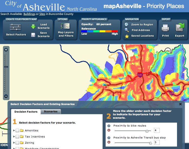 Figure 2.
With Priority Places, a user can create their own set of weighted decision factors to identify the areas best suited to their development obectives.
Figure 2.
With Priority Places, a user can create their own set of weighted decision factors to identify the areas best suited to their development obectives.
“ESRI software doesn't always implement open standards fully,” explained Asheville's Dave Michelson. “We try to use ESRI where it is good, and open source where it works best.” In addition to GeoServer and GeoWebCache, Priority Places includes Ruby on Rails and ArcGIS Server API for Flex. “Using a hybrid application stack of components chosen for their built-in strengths,” Michelson observed, “saved a great deal of development time and produced a very successful application. Priority Places has become an essential resource for Ashville's economic development organizations and investors.” the application won the International Economic Development Council Internet and New Media Award. Priority Places is also a part of MapAsheville. Herbert Stout Award for Visionary use of GIS by Local Government.
Redistributable under the Creative Commons Attribution-Share Alike license.
Asheville Uses Open Source
Table of Contents
Other Case Studies
Greek Regulatory Authority for Energy
The Greek Regulatory Authority for Energy (RAE) Geospatial Map is a web application developed by GET, created during RAE’s Spatial Data Infrastructure implementation. Development was based on: GED SDI Portal®, created and distributed by GET Ltd., under GPL V3, OpenGeo Suite, and Geonetwork OpenSource.
City of New York: A Hybrid Architecture
The City of New York Department of IT built a mapping architecture mixing proprietary and open source components to serve maps for multiple agencies and applications.
MassGIS: A GeoServer Enterprise Story

OpenGeo provides enterprise GeoServer support for Massachussetts' GIS agency.
Rijkswaterstaat: Connected to Open Source
Rijkswaterstaat calls on OpenGeo to build new open source features and add them back into the core project.
FCC Uses Open Source Tools for National Broadband Map
The Federal Communication Commission's National Broadband Map enables the public to see where broadband coverage is available in the United States. The site is completely powered by open source software including PostGIS, GeoServer, OpenLayers, Wordpress, Linux and Apache.
EBServices uses the OpenGeo Suite to deliver a spatial data extra service to SP-Ausnet a power company in the state of Victoria, Australia.

The City of Asheville’s two highly popular GIS applications, Steep Slope and Priority Places, were improved by implementing a hybrid architecture to include both ESRI and open source components.

OpenGeo provides enterprise support to Portland's regional transit authority, who have built a trip planner using the OpenGeo suite of products.
TsuDat: GeoNode and Disaster Modelling

GeoScience Australia and AIFDR have used web delivery to make tsunami modelling available to emergency managers across Australia in a way that was never possible before.

OpenGeo provides a collaborative map for Landgate, Western Australia's land data authority, using OpenLayers and a Versioning extension to the Web Feature Service Standard.
Tike : GeoServer Enterprise Support

Finnish IT agency Tike brings in OpenGeo to provide production support for GeoServer and custom development of web front-end tools.

International technical consulting firm Sweco hires OpenGeo to build cutting edge feature editing capabilities to the OpenLayers core.
Farallon: San Francisco Enterprise Addressing System

Farallon, an OpenGeo partner, develops a secure, web-based solution for the San Francisco Enterprise Addressing System using open source geospatial technology.