Better information is better service.
Public transportation is a tough service to manage. Everyone is a customer, expectations are unrealistically high, and resources are inevitably less than what is really needed. We can’t change the fundamentals, but we can help make them easier to live with.
The fastest, most cost-effective way to improve the quality of your service is to improve your communication with your riders. In partnership with our colleagues at OpenPlans, our solutions can be up and running in no time (without breaking your budget) and will change the way your riders see and use your system. By giving your riders the information they need, when they need it, they will ride more, and appreciate more what your agency does for them and your locality.
Learn more about how we work with forward-thinking public transportation agencies to develop open technology solutions, including:
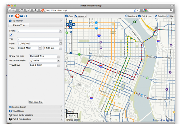
- Interactive system maps offering riders all of your most important route, schedule, transfer, accessibility, and service alert information.
- Multi-modal trip planning that communicates transit schedule, travel, and map information in one standards-based, affordable package that any agency can use.
- Real-time vehicle location services that can aggregate data from existing AVL systems or integrate with inexpensive in-bus hardware to provide up-to-the-minute vehicle location information to riders.
Case Studies
OpenGeo provides enterprise support to Portland's regional transit authority, who have built a trip planner using the OpenGeo suite of products.
Contact
For more information, or to learn more about how OpenGeo can help your agency, please contact us.