The New York City Department of Information Technology and Telecommunications (DoITT) oversees the City's use of existing and emerging technologies in government operations, and its delivery of services to the public. Within DoITT, Citywide GIS provides enterprise-wide support for geospatial applications -- developing and hosting a digital map and geo-referenced data along with associated tools and applications.
DoITT designed a new web mapping architecture, that would overlay vector information on top of cached map tiles. By sharing the tiles among applications, but allowing different overlays, the architecture could be used by multiple agencies, yet retain a consistent look and feel and be centrally maintained.
Colin Reilly is the Director of the Citywide GIS program, “Our plan for this new application and others to follow was to use a WFS and convert GML to VML/SVG over a map cache to provide the desired map experience. In selecting software that could publish geospatial data as WFS. We looked at ESRI's ArcGIS Server among others. ArcGIS Server did not function properly on our UNIX environment so we continued our search. We came upon Geoserver as we expanded our search to open source.”
DoITT deployed Geoserver on top of an Oracle database with geographic data stored in SDO geometry columns. Because Geoserver works natively with Oracle, there is no need for an extra layer of software, such as ArcSDE, to mediate the connection. Geoserver provides OGC standard Web Feature Service access to the data in Oracle, returning the features as GML.
As the new architecture was developed, DoITT formalized the design for in-house re-use, as the WebMap framework. WebMap has now been used to develop several different agency, including the core NYCityMap and the NYC*scout for the Mayor's Office.
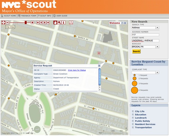
The vector overlays pop out when you try out the sites. Map features are “live”, they active with mouse rollovers and can provide immediate user feedback without requiring a server-side query.
Open source is catching on in New York City, and Reilly predicts future projects GIS may leverage it even more. “We currently use a suite of open source tools and as new needs arise look first to open source options before investigating traditional software. The cost advantages of open source works well within our business plan. Saving money is always well received.”
Other Case Studies
Greek Regulatory Authority for Energy
The Greek Regulatory Authority for Energy (RAE) Geospatial Map is a web application developed by GET, created during RAE’s Spatial Data Infrastructure implementation. Development was based on: GED SDI Portal®, created and distributed by GET Ltd., under GPL V3, OpenGeo Suite, and Geonetwork OpenSource.
City of New York: A Hybrid Architecture
The City of New York Department of IT built a mapping architecture mixing proprietary and open source components to serve maps for multiple agencies and applications.
MassGIS: A GeoServer Enterprise Story

OpenGeo provides enterprise GeoServer support for Massachussetts' GIS agency.
Rijkswaterstaat: Connected to Open Source
Rijkswaterstaat calls on OpenGeo to build new open source features and add them back into the core project.
FCC Uses Open Source Tools for National Broadband Map
The Federal Communication Commission's National Broadband Map enables the public to see where broadband coverage is available in the United States. The site is completely powered by open source software including PostGIS, GeoServer, OpenLayers, Wordpress, Linux and Apache.
EBServices uses the OpenGeo Suite to deliver a spatial data extra service to SP-Ausnet a power company in the state of Victoria, Australia.

The City of Asheville’s two highly popular GIS applications, Steep Slope and Priority Places, were improved by implementing a hybrid architecture to include both ESRI and open source components.

OpenGeo provides enterprise support to Portland's regional transit authority, who have built a trip planner using the OpenGeo suite of products.
TsuDat: GeoNode and Disaster Modelling

GeoScience Australia and AIFDR have used web delivery to make tsunami modelling available to emergency managers across Australia in a way that was never possible before.

OpenGeo provides a collaborative map for Landgate, Western Australia's land data authority, using OpenLayers and a Versioning extension to the Web Feature Service Standard.
Tike : GeoServer Enterprise Support

Finnish IT agency Tike brings in OpenGeo to provide production support for GeoServer and custom development of web front-end tools.

International technical consulting firm Sweco hires OpenGeo to build cutting edge feature editing capabilities to the OpenLayers core.
Farallon: San Francisco Enterprise Addressing System

Farallon, an OpenGeo partner, develops a secure, web-based solution for the San Francisco Enterprise Addressing System using open source geospatial technology.