As part of efforts by the Regulatory Authority for Energy (RAE) to implement a spatial data infrastructure, GET Ltd. (an OpenGeo partner) developed the RAE Geospatial Map using the OpenGeo Suite and other open source technologies. This web application represents one of the first efforts in the public sector to comply with the INSPIRE Directive and Greek law No.3882/2010 to make information accessible to the Greek public.
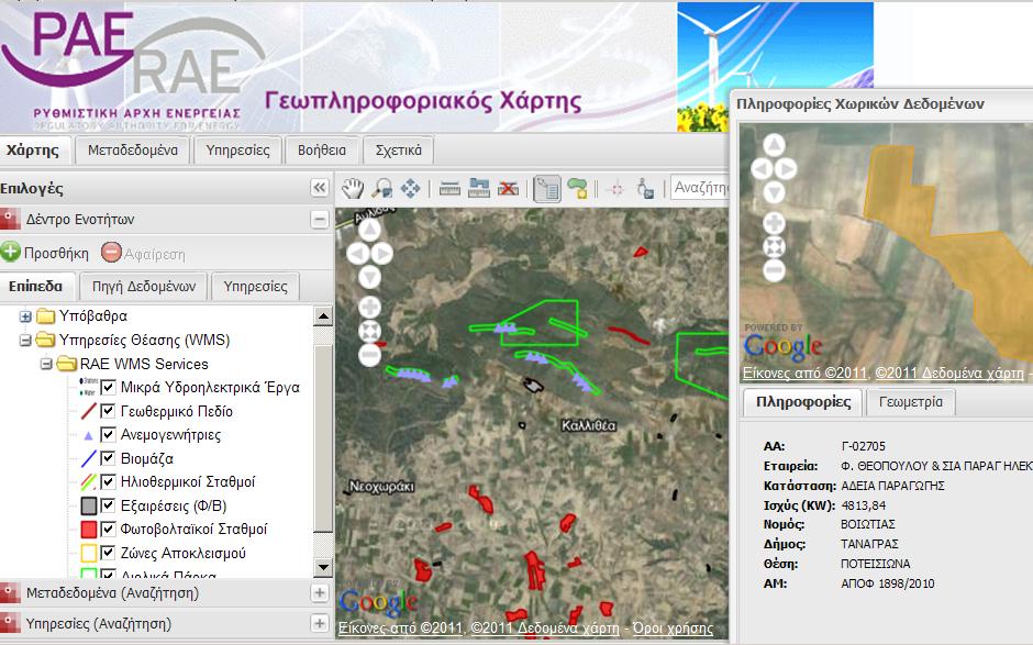 Figure 1.
The RAE Geospatial Map enables users to search, visualize and retrieve information from RAE’s resources.
Figure 1.
The RAE Geospatial Map enables users to search, visualize and retrieve information from RAE’s resources.
Problem Statement
![]() The Regulatory Authority for Energy (RAE) is an independent administrative authority in Greece whose main duties include monitoring the operations of the various sectors that comprise the energy market, including: electricity, natural gas, oil products, renewable energy sources, electricity cogeneration, heat and others. RAE collects and processes information from private utilities in the energy sector while respecting the confidentiality of those in the energy industry. Under pressure to comply with Greek law No.3882/2010, RAE began researching ways to make their data more accessible.
The Regulatory Authority for Energy (RAE) is an independent administrative authority in Greece whose main duties include monitoring the operations of the various sectors that comprise the energy market, including: electricity, natural gas, oil products, renewable energy sources, electricity cogeneration, heat and others. RAE collects and processes information from private utilities in the energy sector while respecting the confidentiality of those in the energy industry. Under pressure to comply with Greek law No.3882/2010, RAE began researching ways to make their data more accessible.
RAE sought to share geospatial information related to their wide-ranging responsibilities, which include: interconnection capacity, the time taken by Transmission System Operators (TSO) and Distribution System Operators (DSO) for connections between users, repairs to the network, the publication of all appropriate information by TSOs and the DSOs, the terms and tariffs for third-party access, the unbundling of accounts, the level of transparency and competition in the energy market and the security of supply.
The Open Source Solution
The RAE Geospatial Map provides user-friendly tools for navigating, querying, searching, measuring and selecting areas of interest. Using the map, RAE’s customers can be informed about the status of their energy facilities and can search, visualize and retrieve information from RAE’s resources.
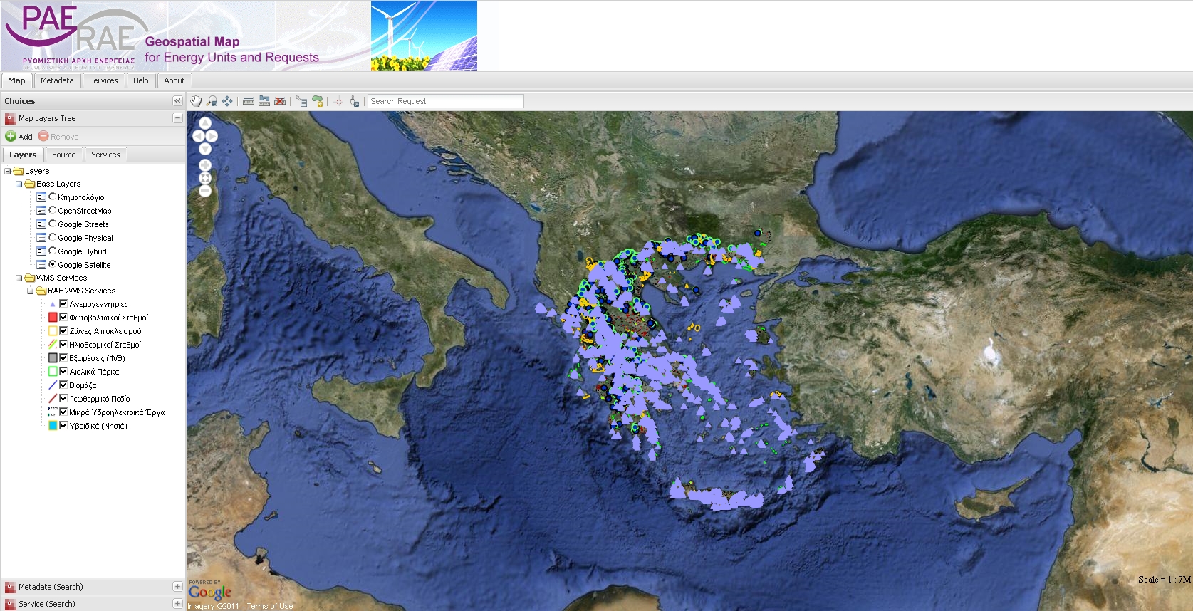 Figure 2.
Layers and base map are chosen with the left hand menu. Screenshot is of actual Greek utility data on the live site.
Figure 2.
Layers and base map are chosen with the left hand menu. Screenshot is of actual Greek utility data on the live site.
But the RAE Geospatial Map is not just a GIS web application, it also provides for consuming data and metadata into third-party spatial data infrastructures. Using OGC standards (WMS, WFS, CSW), developers can pull data from RAE directly into their own web-enabled geospatial software projects. The RAE Geospatial Map provides public access to geospatial data using many open source technologies, including:
- GET SDI Portal, created and distributed by GET Ltd.
- OpenGeo Suite
- GeoNetwork OpenSource
Features
Basic features include:
- Data visualization
Data discovery based on:
- Spatial criteria
- RAE's business logic
Data and service discovery using:
- RAE's Catalogue
- Third party catalogues
Client-side technologies:
- OpenLayers
- ExtJS
- GeoEXT
- Proj4JS
Server-side technologies:
- OpenGeo Suite
- Geonetwork OpenSource
Table of Contents
Other Case Studies
Greek Regulatory Authority for Energy
The Greek Regulatory Authority for Energy (RAE) Geospatial Map is a web application developed by GET, created during RAE’s Spatial Data Infrastructure implementation. Development was based on: GED SDI Portal®, created and distributed by GET Ltd., under GPL V3, OpenGeo Suite, and Geonetwork OpenSource.
City of New York: A Hybrid Architecture
The City of New York Department of IT built a mapping architecture mixing proprietary and open source components to serve maps for multiple agencies and applications.
MassGIS: A GeoServer Enterprise Story

OpenGeo provides enterprise GeoServer support for Massachussetts' GIS agency.
Rijkswaterstaat: Connected to Open Source
Rijkswaterstaat calls on OpenGeo to build new open source features and add them back into the core project.
FCC Uses Open Source Tools for National Broadband Map
The Federal Communication Commission's National Broadband Map enables the public to see where broadband coverage is available in the United States. The site is completely powered by open source software including PostGIS, GeoServer, OpenLayers, Wordpress, Linux and Apache.
EBServices uses the OpenGeo Suite to deliver a spatial data extra service to SP-Ausnet a power company in the state of Victoria, Australia.

The City of Asheville’s two highly popular GIS applications, Steep Slope and Priority Places, were improved by implementing a hybrid architecture to include both ESRI and open source components.

OpenGeo provides enterprise support to Portland's regional transit authority, who have built a trip planner using the OpenGeo suite of products.
TsuDat: GeoNode and Disaster Modelling

GeoScience Australia and AIFDR have used web delivery to make tsunami modelling available to emergency managers across Australia in a way that was never possible before.

OpenGeo provides a collaborative map for Landgate, Western Australia's land data authority, using OpenLayers and a Versioning extension to the Web Feature Service Standard.
Tike : GeoServer Enterprise Support

Finnish IT agency Tike brings in OpenGeo to provide production support for GeoServer and custom development of web front-end tools.

International technical consulting firm Sweco hires OpenGeo to build cutting edge feature editing capabilities to the OpenLayers core.
Farallon: San Francisco Enterprise Addressing System

Farallon, an OpenGeo partner, develops a secure, web-based solution for the San Francisco Enterprise Addressing System using open source geospatial technology.