Style and Control
Our outreach team works with the OpenGeo Suite to build mapping sites for clients around the world. Each application is a unique combination of cartographic needs and user interface needs.
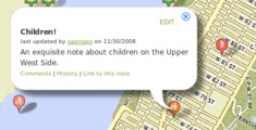
The Right Interface
 Attractive, interactive applications aren't the exclusive domain of the desktop anymore. With GeoExt and OpenLayers (part of the OpenGeo Suite), interactive desktop-style applications are possible using pure web technology.
Our development team includes core OpenLayers and GeoExt developers who can craft an attractive custom application to your specifications.
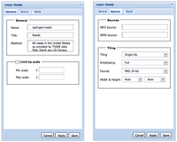
The Right Map
 Sometimes the default styles provided by Google or Microsoft don't fit your site, or the kinds of data you are displaying. What to do? Roll your own! With the OpenGeo Suite you can render and serve your own basemap tiles from a high-performance cache.
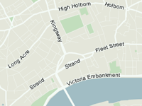
Check out our rendering of OpenStreetMap data.
Our Web Map Experts
Andreas Hocevar
Andreas is an active OpenLayers and GeoExt steering committee member and committer. He has been working in geospatial for almost 20 years, and is a frequent teacher and speaker.
Bart van den Eijnden
Bart helps to develop OpenLayers and GeoExt, and has a strong interest in open standards.
Tim Schaub
Tim serves as CTO of OpenGeo, and is an active developer and steering committee member for OpenLayers. Before joining OpenGeo, Tim worked on numerous GIS development projects as a consultant and researcher.
Get web map help now!
Making Beautiful Maps
Attractive web maps are built from collections of styles and data. It takes multiple layers of data at appropriate scales, and multiple styles working in harmony to turn out a great-looking map.